News

CAGIS Researchers Present Cutting-Edge Work at AAG 2025 in Detroit
Several members of the Center for Applied Geographic Information Science (CAGIS) at UNC Charlotte proudly represented the center at the 2025 Annual Meeting of the American Association of Geographers (AAG), held in Detroit, Michigan, from March 24 to 28. The AAG Annual Meeting is one of the largest gatherings of geographers, GIScientists, and spatial thinkers […]
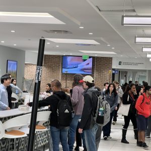
UNC Charlotte Celebrates GIS Day 2024!
On November 20, 2024, the Center for Applied GIScience (CAGIS) and the Department of Earth, Environmental, and Geographical Sciences (EEGS) hosted the annual GIS Day in McEniry Lobby at UNC Charlotte. The event brought together students, faculty, and industry professionals to celebrate the power and potential of Geographic Information Systems (GIS). Competition Highlights The day […]

Celebrate GIS Day 2024 at UNC Charlotte!
Add to Google Calendar Date: November 20, 2024Location: McEniry LobbyTime: 10 AM – 2 PM Join us for an exciting day filled with cutting-edge geospatial technology, hands-on experiences, competitions, career insights, and prizes—including a chance to win a $50 Amazon gift card for two of the GIS Day attendees! This is your chance to dive into the world of GIS, […]

CAGIS Seminar Presents Tianyang Chen “Explicit Incorporation of Spatial Autocorrelation in 3D Deep Learning for Geospatial Object Detection”
Please join CAGIS Seminar August, 30 at 12:00pm! For this seminar we will be hearing Dr. Tianyang Chen discuss his study: Explicit Incorporation of Spatial Autocorrelation in 3D Deep Learning for Geospatial Object Detection Dr. Chen’s research focuses on 3D deep learning, spatial analytics, and geocomputation. He has been actively contributing to the practical applications […]
CAGIS-GeoSAN receives new award to develop Mangrove Spatial Decision Support System
Mangrove forests, which grow in the coastal wetlands of the tropics and sub-tropics, provide essential ecosystem services to humans, ranging from the mitigation of shoreline erosion, to housing nurseries for commercially important fish & shellfish, and by filtering pollutants from land-based runoff. Despite the protective role they play, mangroves worldwide have experienced significant decline, driven […]
Director Shoemaker comments on ongoing losses of CLT’s urban tree canopy
Douglas Shoemaker, director of research and outreach at the Center for Applied GIScience, was featured in a WBTV segment February 2 talking about a recent study that measured the loss of Charlotte’s signature tree canopy. In his interview with Jamie Boll, originally recorded in 2020, Doug remarks on his surprise regarding the magnitude of canopy loss, […]
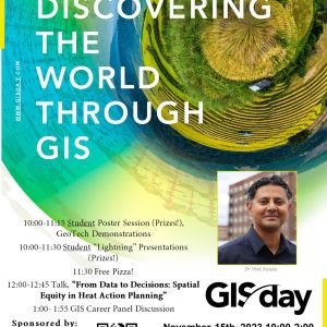
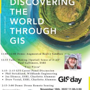
New for GIS Day 2023: Urban Heat theme, Student Competitions
GIS Day 2023 will celebrate innovative applications of geographic information system (GIS) technology in analysis, visualization, gaining insights into geospatial data, and thought leadership across Campus. All events are free to attend. We are pleased to welcome Dr. Vivek Shandas from Portland State University to speak about Urban Heat Islands, and specifically how decision-makers can […]
New funding from NCDOT: Spatially Explicit Deep Learning-based Underground Pipe Prediction for Urban Stormwater Management (Deeppipe)
Stormwater management is an essential urban infrastructure as it helps protects people and property from flooding, improves water quality, and reduces the risk of infrastructure damage. However, stormwater pipeline networks that create these services are complex underground systems that require regular inspection to guide maintenance and maintain integrity. Because the pipeline systems are underground, accurately […]
CAGIS awarded “Ignite for Centers” funding to accelerate research in emerging geospatial technologies and analytics: GeoSAN
July 6, 2023: Charlotte’s Division of Research has funded a new initiative within the Center for Applied GIScience designed to accelerate conceptualization and development of research leveraging emerging geospatial technologies and analytics. GeoSAN, or the Geospatial Sensing and ANalytics initiative, is the conception of Drs. Wenwu Tang (GEOG, CAGIS) and Shen-en Chen (CEE), with contributions […]
UNC Charlotte GIS Day
November 16th is GIS Day at UNC Charlotte which will include a number of talks and activities.