Spatial Epidemiology
Our research focuses on answering fundamental epidemiological questions where spatial and spatio-temporal methodology are critical. We are interested in developing new, robust geocomputational methodologies that deepen our understanding on the dynamics of infectious and non-infectious diseases. We are concentrating our efforts in the development of new visualization techniques to detect space-time patterns at different scales (e.g. clusters), and leverage on state-of-the art computational techniques (e.g. cyberGIS, parallel computing) for unusually large datasets. Finally, we disseminate our methods by deploying those on the web. We are interested in students with strong computational, visualization skills and interest in health geography.
|–Current, Active Projects–|
1. Mapping Dengue Fever Outbreaks in Space and Time
We conduct the Space-Time Kernel Density Estimation (STKDE) in a parallel computational framework to map space-time clusters of dengue fever in an urban environment of Colombia. We extract intricate disease dynamics in an interactive manner, using a powerful 3D environment (Figure 1). Findings from our work can help better understand the dynamics of a quickly spreading disease.
CAGIS members: Dr. Eric Delmelle, Coline Dony, Meijuan Jia, Dr. Tang.
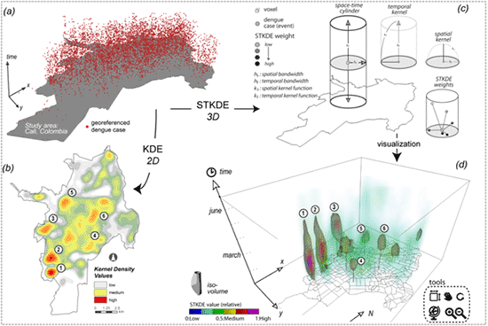
Figure 1: Space-time distribution of dengue fever cases for Cali, Colombia for January to June 2010 in (a), KDE in (b), STKDE concept in (c) and STKDE visual in (d) using an iso-volume value of 0.5 (time granularity: days). Clusters 1 and 2 are more elongated than clusters 5 or 6, but cannot be inferred from (b).
2. Parallel Spatial Computing Solution for Space-Time Algorithms
Spatial and Spatio-temporal algorithms are computationally intensive. For instance, to evaluate uncertainty in clustering tests, one must conduct a large number of Monte-Carlo simulations. We are interested in developing robus computational methods to facilitate these simulations (Figure 2).
CAGIS members: Dr. Eric Delmelle, Coline Dony, Meijuan Jia, Dr. Tang.
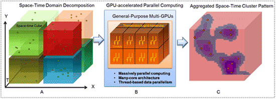
Figure 2. Parallel space-time cluster analysis accelerated using multi-GPUs (STKDE is used as an example). 3D space-time decomposition (A); computed on GPU devices in a parallel manner (B); cluster outcomes of cubes are aggregated to form the final space-time cluster pattern (C)).
3. Impact of space-time uncertainties on the detection of dengue fever outbreaks
We evaluate the impact of positional and temporal inaccuracies on the mapping and detection of potential outbreaks of dengue fever. To test the robustness of disease intensities in space and time when accounting for the potential space-time error, each dengue case is perturbed using Monte-Carlo simulations. A space-time kernel density estimation (STKDE) is conducted on both perturbed and observed sets of dengue cases to extract, map and compare the intensity of disease outbreaks (Figure 3).
CAGIS members: Dr. Eric Delmelle, Coline Dony, Meijuan Jia, Dr. Tang.
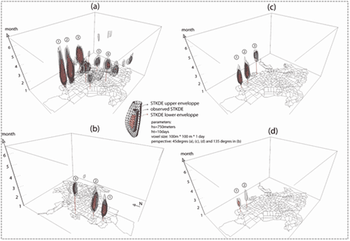
Figure 3: Iso-volumes on geocoded dengue cases (in grey). Same value iso-volumes are generated for STKDE on the perturbed dengue cases, showing minimum extent of the cluster (in red) and maximum extent of the cluster (in black). Iso-volume cut-off value of 0.5 in (a), 0.7 at a view angle of 45° in (b), 0.7 at a view angle of 135° in (c) and 0.9 in (d).
4. Prediction of Dengue Fever Outbreaks in Urban Environments of Colombia
We develop predictive models of dengue incidence rate, based on relevant local weather and regional climate parameters. We analyze time series of epidemiological and meteorological data for the dynamic urban environment of Cali, Colombia from January 2000 through December 2011. We develop environment-based multivariate auto-regressive forecast models that allow dengue outbreaks to be anticipated from 2 weeks to 6 months in advance (Figure 4). Our results have the potential to enhance existing dengue early warning systems, which can ultimately be used to support public health decisions regarding the timing and scale of vector control efforts.
CAGIS members: Dr. Eric Delmelle, Dr. Matt Eastin.
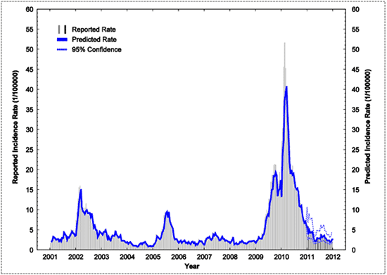
Figure 4: Reported and predicted intra-seasonal dengue incidence rates from 2001—2011. The reported population-adjusted bi-weekly dengue incidence rates (DPOP) during the model development period (2001–2010) are shown by vertical gray lines, while reported rates during the model verification period (2011) are shown by vertical black lines.
5. On-line Tools for the Monitoring of Dengue Fever Outbreaks
One important component of research within the Center for Applied GIS is the development of tools and techniques available for different communities. This is critical to disseminate findings among different communities, and foster knowledge discovery. We have developed an interactive online GIS application with the objective to monitor dengue fever outbreaks at different scales. Our on-line toolkit allows to 1) deploy and share epidemiological data information at the individual point level, 2) conduct temporal and spatial queries on dengue fever events, 3) generate spatial distribution maps in a raster format across a region within a reasonable computational time to better determine the occurrence of hot spots and 4) visualize space-time connection among disease events locally (Figure 5).
CAGIS members: Dr. Delmelle, Hongmei Zhu, Dr. Wenwu Tang.
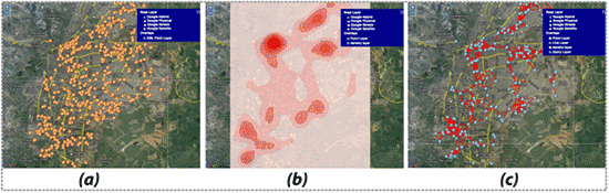
Figure 5: Maps generated from the on-line dengue fever monitoring toolkit: a) dengue fever cases for the city of Cali, Colombia for the first two weeks of February 2010 (n=649). b): kernel density estimation with a radius of 1,000 meters. c): space-time connections of 5 days and 1,000 meters.
|–Completed Projects–|
Modeling Travel Impedance to Medical Care for Children with Birth Defects Using Geographic Information Systems.
Children with birth defects face significant geographic barriers accessing medical care and specialized services. Using a Geographic Information Systems (GIS)-based approach, we estimate travel time and distance to access medical care for children born with birth defects in Florida (e.g spina bifida). Infants with birth defects living in rural areas in Florida experienced greater travel times compared with those living in urban areas. GIS methods are important in evaluating accessibility and geographic barriers to care and could be used among children with special health care needs.
CAGIS members: Dr. Eric Delmelle, Coline Dony.
Assessing socioeconomic vulnerability to dengue fever: statistical vs. expert-based modeling
We develop a methodology for the spatial assessment of current socioeconomic vulnerabilities to dengue fever in Cali, Colombia. We develop a spatial approach for both expert-based and purely statistical-based modeling of current vulnerability levels across neighborhoods of the city using a GIS. The results of both approaches are comparatively evaluated by means of spatial statistics. A web-based approach is proposed to facilitate the dissemination of the output vulnerability index to the community.
CAGIS members: Dr. Eric Delmelle.