GeoSAN: Center for Geospatial Sensing and Analytics (Ignite Center Initiative)
Charlotte’s Division of Research has funded a new initiative within the Center for Applied GIScience designed to accelerate conceptualization and development of research leveraging emerging geospatial technologies and analytics. GeoSAN, or the Geospatial Sensing and ANalytics initiative, is the conception of Drs. Wenwu Tang (GEOG, CAGIS) and Shen-en Chen (CEE), with contributions from a range of faculty representing several colleges, including the School of Data Science (SDS) and the College of Computing and Informatics (CCI). This funding will seed new collaborations between the College of Humanities & Earth and Social Sciences (CHESS) College of Humanities, Earth and Social Sciences’ (CHESS) Center for Applied GIScience (CAGIS), the William States Lee College of Engineering, and new Ignite Centers.
GeoSAN will contribute to all the Research Excellence categories of UNC Charlotte with a concentration on the following areas of focus and distinction: smart and sustainable cities, transportation and advanced mobility, AI and automation, and climate change and resilience. Initial seed monies will be used to connect with other recently designated ICs: the Center for Environmental Health, CIPHER, the Charlotte Aviation Innovation and Research Institute, and Migration and Diaspora Studies.
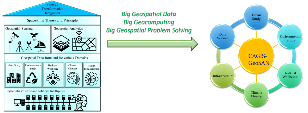
The pace of change in geospatial analytics and innovation as well as the magnitude of emerging challenges has guided the strategic thinking process behind GeoSAN. Specifically, the rapid development and ubiquity of “location aware” sensing, computing, and networking technologies has made geospatial data increasingly available. These “big data” have huge potential to empower and facilitate problem solving within current human, economic and environmental dilemmas.
However, the acquisition, processing, analysis or modeling, and mapping of these geospatial data pose a prohibitive computational challenge. Geospatial sensing and analytics, driven by cutting-edge cyberinfrastructure and artificial intelligence (AI) technologies together with space-time theories and principles, provide substantial support for the resolution of the challenges facing geospatial data handling and its domain-specific applications. IC grants focus on early-stage, pilot, and established University Centers to support and incentivize interdisciplinary research collaborations. The ultimate goal is to help accelerate UNC Charlotte’s success in attracting extramural funding, especially in the areas of focus and distinction identified in the Top-tier Research Commission Report.
Center for Geospatial Sensing and Analytics (GeoSAN) – Paving a Geospatial Way to Top Tier Research Excellence
Names, departments, and institutional affiliations of participating personnel.
| Wenwu Tang (PI) | GES, CAGIS, SDS | Missy Eppes | GES |
| Shenen Chen (Co-PI) | Civil and Environmental Engineering | Cynthia Gibas | Bioinformatics |
| Jean-Claude Thill | GES, SDS | Dongsong Zhang | Business, SDS |
| Matt Eastin | GES | Michael Ewers | GES |
| Don Chen | ETCM | Jessica Schlueter | Bioinformatics |
| Yuting Chen | ETCM | Eric Delmelle | GES |
| Lei Zhu | SEEM, SDS | Isabelle Nilsson | GES |
| Craig Allan | GES, CAGIS | Colleen Hammelman | GES, CHARP |
| Artur Wolek | MEES | Mariya Munir | CEE |
| Andrew Willis | ECE | Aidong Lu | CS |
| Akinwumi Ogundiran | Africana Studies | Jing Yang | CS |
| Doug Shoemaker | CAGIS | Anthony Fodor | Bioinformatics |
| Ahmed Helmy | CCI | Casey Davenport | GES |
| Pat Fall | GES | Scott Hippensteel | GES |
| Sandra Clinton | GES | Stephanie Pilkington | ETCM |
| Bill Graves | GES | Srinivas Akella | CS |
| Sara Gagne | GES | Michelle Zuniga | GES |
| Michael Turner | Criminal Justice | Fushcia Hoover | GES |
| Shannon Reid | Criminal Justice | Heather Smith | GES |