News
Please join us this Wednesday at 1:30 when we hear Geomorphologist Dr. Andy Mills talk about assessing risk for engineering projects using cutting-edge technologies. The Application of Geospatial Acquisition Technologies to Ground Risk Assessment in Offshore and Onshore Settings Abstract This seminar will present several case studies utilizing remotely acquired data to evaluate ground risks […]
Please join us this Wednesday at 1:30 when we hear NASA scientist Atticus Stoval talk about new methods in measuring 3D forest structure using exciting tools like Terrestrial LiDAR! Abstract Forests are known as the lungs of the Earth, at the front lines of climate change, while providing a litany of ecosystem services, natural resources, […]
Please join us Wednesday at 1:30 when we hear Dr. Narcisa Pricope from UNCW’s Socio-Environmental Analysis Lab talk about her strategies for conducting multiscale analyses in complex socio-ecological systems, such as those in the trans-frontier region of southern Africa. Dr. Pricope embraces the concept of “Big Tent” research, where collaborations tackle “wicked” problems (as defined […]
We invite you to participate in Wednesday’s CAGIS Virtual Seminar where we hear from Dr. Chen Chen, Assistant Professor in the Department of ECE at UNCC, talk about his team’s recent effort on cross-view image geo-localization using advanced deep learning algorithms. Join with Google Meet meet.google.com/pid-xjwj-vwz Up to 250 participants Meeting ID meet.google.com/pid-xjwj-vwz […]
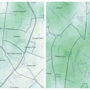
New analyses conducted by the Center of Applied GIS reveals less access to urban tree canopy in many of Charlotte’s underserved nieghborhoods. These findings contexualize a study by UVM’s Spatial Analysis Lab (here) that found the majority of tree loss in Charlotte between 2012 and 2018 occured in more affluent nieghborhoods, likely caused by storm […]
Recent advances in RNA testing has opened the possibility of detecting the COVID-19 virus in wastewater, a method likely to speed the identification of clusters, and target testing. This is especially important on college campuses, including our own, where in-class attendance increases the risk for transmission. CAGIS Executive Director Wenwu Tang, and Faculty Associate Eric […]
Dear colleagues, The open access journal ISPRS International Journal of Geo-Information (ISSN 2220-9964, IF 2.239) is pleased to announce that we have launched a new Special Issue entitled ““. Relevant topics include, but not limited to: Applications of artificial intelligence techniques Applications of cyberinfrastructure Geovisualization and geovisual analytics Innovative algorithms for spatial analysis and modeling […]
A new study finds over three football fields worth of trees were lost per day between the end of the Great Recession and 2018. According to Dr. Shoemaker, concerted action is needed now to meet Charlotte’s “50% by 2050” resolution. Anecdotally, we have all seen a lot of tree loss since the big development reboot […]
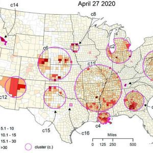
In response to the COVID-19 global pandemic, recent CAGIS graduates Alex Hohl and Michael Desjardins teamed-up with Faculty Associate Eric Delmelle to conduct geostatistical analyses of outbreaks in the United States. The team then produced maps of “active” and “emerging” clusters nationwide needed to allocate medial resources in a timely matter. They published their results […]
We welcome UNCC GES alums Danny Yonto and Claire Schuch to our CAGIS Seminar to give a talk regarding their efforts to map gentrification in Charlotte. Gentrification has been increasingly studied, but disagreement continues on how best to define and measure it, particularly in regards to how scale influences detection. In this presentation we hear […]
We welcome Ph.D. Candidate Michael Desjardins to hear about his investigations into the time/space dynamics of dengue, chikungunya and Zika outbreaks in Cali, Colombia. Abstract: Dengue, chikungunya, and Zika are mosquito-borne diseases that infect an estimated 390 million people worldwide each year, and 100,000 in Colombia alone. Despite the human costs, these diseases are particularly […]
We invite you to an interesting, two-part Seminar next week which discusses new applications for unmanned aerial vehicles (UAVs), sometimes referred to as “drones”. In part 1, Dr. Srinivas Akella talks about coordinating multiple UAVs for disaster response. In part 2, Dr. Yutin Chen describes the new role UAVs are playing in the construction industry, […]
We are pleased to welcome Justin Lane from the Urban Institute for our next CAGIS Seminar. Justin will be talking about one of the most influential mapping projects to date, the Opportunity Atlas, with special attention to how the maps are being used in Charlotte. We would enjoy seeing you at 1:00 in the CAGIS […]

By Tianyang Chen. Editors’ note: Tianyang Chen is 2nd year PhD student and CAGIS research assistant advised by Dr. Wenwu Tang. This past summer, Chen attended the SDSC Summer Institute, a week-long workshop that focuses on a broad spectrum of introductory-to-intermediate topics in high performance computing and data science. It was a beautiful weather, sunny […]
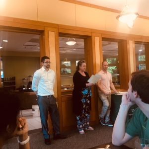
Charlotte, May 2019. During the Department of Geography and Earth Sciences’ annual awards banquet, CAGIS researcher Michael Desjardins received one of the two “Outstanding Doctoral Student in Geography” awards. This annual award recognizes and honors the outstanding performance and contributions of a PhD in Geography student whose academic excellence, service, and leadership have made an […]
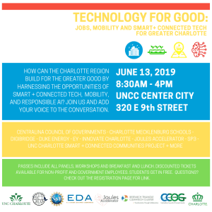
We cordially invite you to attend Technology for Good: Jobs, Mobility and Smart + Connected Tech for Greater Charlotte Summit to be held on October 9th at UNC Charlotte’s Center City Building in Uptown. In cooperation with the Center for Applied GIScience (CAGIS), our NSF Smart and Connected Communities Team has created a summit and […]
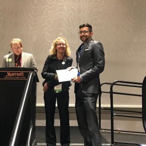
Washington DC, April 2019. CAGIS researcher Michael Desjardins (PhD Student) received a 2019 AAG Dissertation Research Grant to support his dissertation titled “A mixed-methods approach for vector-borne disease surveillance in Colombia”. From Desjardin’s upcoming dissertation: Vector-borne diseases (VBDs) affect more than 1 billion people a year worldwide, cause over 1 million deaths, and result in […]
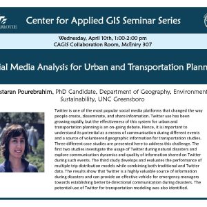
On Wednesday, April 10, PhD Candidate Nastaran Pourebrahim from UNC Greensboro will present, “Social Media Analysis for Urban and Transportation Planning” Twitter is one of the most popular social media platforms that changed the way people create, disseminate, and share information. Twitter use has been growing rapidly, but the effectiveness of this system for urban […]
Call for paper: Special issue of Sustainability (09-26-2018)