News
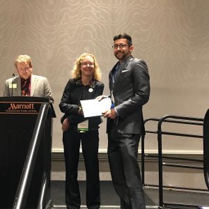
CAGIS Researcher Awarded as Outstanding Scholar
Charlotte, May 2019. During the Department of Geography and Earth Sciences’ annual awards banquet, CAGIS researcher Michael Desjardins received one of the two “Outstanding Doctoral Student in Geography” awards. This annual award recognizes and honors the outstanding performance and contributions of a PhD in Geography student whose academic excellence, service, and leadership have made an […]
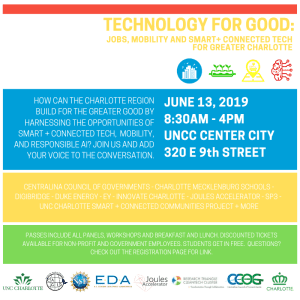
CAGIS to Co-Host Smart City Summit “Technology for Good” October 9th
We cordially invite you to attend Technology for Good: Jobs, Mobility and Smart + Connected Tech for Greater Charlotte Summit to be held on October 9th at UNC Charlotte’s Center City Building in Uptown. In cooperation with the Center for Applied GIScience (CAGIS), our NSF Smart and Connected Communities Team has created a summit and […]
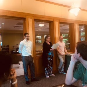
CAGIS Researcher Receives 2019 AAG Dissertation Grant
Washington DC, April 2019. CAGIS researcher Michael Desjardins (PhD Student) received a 2019 AAG Dissertation Research Grant to support his dissertation titled “A mixed-methods approach for vector-borne disease surveillance in Colombia”. From Desjardin’s upcoming dissertation: Vector-borne diseases (VBDs) affect more than 1 billion people a year worldwide, cause over 1 million deaths, and result in […]
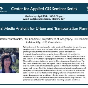
CAGIS Seminar: Nastaran Pourebrahim presents on mapping social media data
On Wednesday, April 10, PhD Candidate Nastaran Pourebrahim from UNC Greensboro will present, “Social Media Analysis for Urban and Transportation Planning” Twitter is one of the most popular social media platforms that changed the way people create, disseminate, and share information. Twitter use has been growing rapidly, but the effectiveness of this system for urban […]
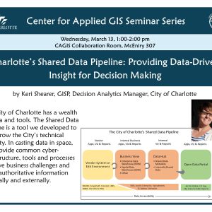
Keri Shearer talks about GIS and Charlotte’s Shared Data Pipeline
Please join us tomorrow to hear Keri Shearer from the City of Charlotte talk about the City’s Shared Data Pipeline. The City of Charlotte has a wealth of data and tools. The Shared Data Pipeline is a tool we developed to help grow the City’s technical capacity. In casting data in space, we provide common […]
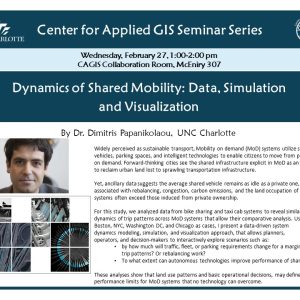
Are Mobility on Demand (MoD) systems more sustainable?
Please join us on February 27th to hear Dr. Dimitris Papanikolaou present his comparative analyses of MoDs and traditional ride hailing services.
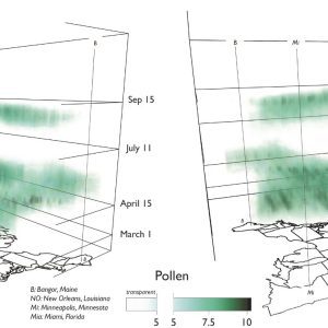
The Where and When of Hay Fever
Charlotte, December 2018. Allergic rhinitis (or hay fever) effects roughly 15 out of 100 Americans, but sufferers have had little guidance on how to avoid the pollen outbreaks that aggrevate thier symptoms. Blooms of trees, grasses and herbaceous plants are to blame, but seasonality and variations in climate have made it hard to understand where […]
Call for Book Chapter: High-performance Computing for Geospatial Applications
An edited book entitled “High Performance Computing for Geospatial Applications” has been approved by Springer. Editors are Drs. Wenwu Tang (University of North Carolina at Charlotte) and Shaowen Wang (University of Illinois at Urbana-Champaign). Here is the background information of the book. High Performance Computing (HPC) allows for the use of advanced computer systems to […]
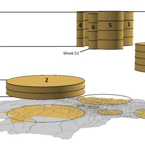
CAGIS researcher uses space-time visualizations to target outbreaks of mosquito-borne illnesses in Colombia
Charlotte, October 2018. In a new paper, CAGIS researcher and lead author Michael Desjardins describes new methods to visualize the complex, spatio-temporal dynamics of outbreaks in mosquito-born illnesses in Colombia. Outbreaks of chikungunya and dengue fever (both transmitted by the same two mosquitoes) occur unevenly across municipalities both geographically and in timing, presenting substaintial challenges […]
Call for Paper: Sustainability Special Issue: Applications of Artificial Intelligence in the Study of Land Use and Land Cover Change
Artificial intelligence has been increasingly used to support the study of coupled land systems, which are complex adaptive spatial systems driven by land use and land cover change. These artificial intelligence approaches comprise: 1) Machine learning (e.g., artificial neural networks, decision trees), 2) Evolutionary computation (e.g., genetic algorithms, evolutionary algorithms), 3) Distributed artificial intelligence (e.g., […]